79 Resources Ltd., (Stock Exchange:N/A), NI 43 101, May 5th, 2020
- Technical Report for Louise Lake Property, Cu, Mo, Au, calc-alkaline suite porphyry system, British Columbia
- No Resources Estimated
SUMMARY
1 INTRODUCTION
In August 2019,
79 Resources Ltd. (79) of Vancouver, British Columbia, Canada, commissioned
Aurora Geosciences Ltd. (Aurora) to complete a National Instrument 43-101
Technical Report on the Louise Lake property. This is a “Property of Merit”
based on the presence of the “Main Zone” copper (Cu) - molybdenum (Mo) - gold
(Au) - silver (Ag) porphyry deposit in the north-central area of the property.
The Louise Lake
property is located 35 air-km west of the Town of Smithers, British Columbia,
Canada. The property comprises eight mineral claims comprising 1,825.12
hectares (Ha) held by Messrs. Steven Scott and Brian Scott. In July of 2019, 79
Resources Ltd. (“79”) entered into an option agreement to gain a 75% interest
in the property. In August 2019, “79” commissioned Aurora to conduct
due-diligence mapping and rock sampling across the surface expression of the
Main Zone, and to conduct preliminary surface exploration southeast of the
Louise Lake waterbody. In November, a Phase 2 program of ground magnetometer
surveying, centered on the “Argillic Hill” area, was completed.
The southern part
of the property is accessible by logging roads extending west from Smithers,
although the Main Zone is accessible by helicopter only. Terrain is gentle to
moderate in the Main Zone area, but considerably more rugged in the
southeastern area. The property is located along the inland limit of the coastal
pacific climatic influence, while to the east, the climate trends towards a
sub-arctic continental climate.
Despite a history
of significant exploration including delineation-style diamond drilling from
1970 through 2008, there are no environmental liabilities on the property. The
2019 program required no permitting. However, proposed diamond drilling
programs for 2020 will require permitting from the Department of Energy, Mines
and Petroleum Resources, Government of British Columbia, Canada. A security
bond will also be required once the program is permitted.
2 HISTORY
The present
property area was first staked as the LOU claims in 1968 by Mastodon-Highland
Bell Mines (Mastodon). In 1969, Mastodon completed geological mapping, soil
geochemical and Induced Polarization (IP) geophysical surveying and trenching,
the latter exposing a 490 m X 245 m area of low-grade Cu-Mo mineralization,
called the “Main Zone”, north of the Coal Creek fault.
Late in 1969,
Canadian Superior Exploration Ltd. optioned the property, and in 1970,
completed a 17-hole, 2,021 m diamond drilling program, with 16 holes focusing
on or close to the Main Zone. Results were deemed sub-economic and the claims
were allowed to lapse.
In 1975, Granby
Mining Corporation re-staked the area as the 500-hectare (ha) LOUISE 1 and 2
claims and conducted soil geochemical surveying in 1976, delineating a 650 m X
300 m Cu soil geochemical anomaly.
In April 1979,
the Bethlehem Copper Corporation staked the ROB 1-4 claims, resampled earlier
core and conducted further geochemical and limited IP surveying. The
geochemical survey returned two strongly anomalous Mo values, including one
northwest of Bud Lake. However, the ROB claims were allowed to lapse.
In late November
1979, the LOUISE LAKE claim was transferred to Noranda Exploration Company Ltd (Noranda)
which conducted airborne magnetometer and VLF-EM surveying across the Louise
Lake area. anomalous Cu and Au values from the Main Zone area.
The property was
re-staked in 1986 as the 1,600-ha TENN and TROUT claims by E. Shaede and L.
Warren who then optioned it to Lacana Mining Corporation in 1987, which changed
its name to Corona Gold Corporation (Corona) by 1988. In 1988, Corona conducted
reconnaissance and detailed geological mapping and soil, rock and silt
sampling, identifying numerous Cu ± Mo ± Au anomalies proximal to, but not
always directly overlying, the Main Zone.
In 1989, Corona
completed a five-hole, 916-metre diamond drilling program in the eastern Main
Zone area. All holes returned strongly anomalous Cu-Au ± Mo mineralization with
fairly uniform metal values but lacking notable high-grade zones. In 1989,
Placer Dome Inc. (Placer) conducted a brief property visit followed by a
detailed compilation of existing drill and surface data. Placer determined that
mineralization at Louise Lake has both epithermal and porphyry-style
characteristics, suggesting the Main Zone represents a transitional zone
between upper-levels of a porphyry system and an evolved hydrothermal (epithermal)
zone. Placer believed the Main Zone mineralization to be sub-economic and thus
declined to enter into an acquisition of the property from Corona.
Corona terminated
its option in early 1991. In November 1991, the claims were optioned by New
Canamin Resources Ltd. (New Canamin), who then subsequently entered into an
option with Equity Silver Mines Ltd (Equity). In 1992, Equity conducted two
diamond drilling programs totaling 2,651.6 metres in 13 holes, interpreting
drill results as representing an east-west trending tabular deposit, dipping
shallowly northward. At a 0.2% Cu cut-off, Equity stated that the deposit
contained “estimated resources of 50 million tonnes grading 0.3% Cu and 0.3 g/t
Au with some payable molybdenum”. This is not a compliant resource under NI
43-101 standards and should not be relied upon. Equity drilled one hole to the
east, and intersected a zone referred to as the “Lake Zone”, comprising
chalcopyrite-sphalerite veins with accessory Au and Ag values.
By early 1995,
Global Mineral and Chemical Ltd. (Global) entered into an option agreement to
earn a 100% interest on the TENN and TROUT claims and conducted soil geochemical
sampling. A moderate Zn-in-soil geochemical anomaly was identified about 350 m
south of Louise Lake. In early 1996, Global conducted IP surveying followed by
five diamond drill holes into the Main Zone area. No assessment reports were accessible;
however, news releases stated that two holes were mineralized throughout their
>200-metre extents. In 1998, Global drilled five additional holes to the
east. No major zones were intersected although the company did announce
“interesting but not exciting silver values”
The LOUISE 1-30
claims were staked by January of 2004 by Messrs. B. Kreft and C. Greig. In
January 2004, Firestone Ventures Inc. (Firestone) entered into a joint venture
agreement to obtain a 100% interest in the property and completed a six-hole,
1,718.4 m diamond drilling program focusing on the Main Zone. The program
expanded known dimensions of the zone to the east and west, and confirmed
previously reported results in central areas.
In December 2004,
Firestone signed a “letter of intent” with North American Gem Inc. whereby
North American Gem may earn a 75% interest in the property. In 2005, North
American Gem conducted a sevenhole, 2,412.3 m diamond drilling program,
focusing on further expansion of the Main Zone to the west, east and at depth.
“Main Zone” and surrounding area. This program determined the base of the
deposit to be a flat-lying thrust fault, named the “Terminator”. Results of
this and all earlier programs were incorporated into thefirst Main Zone NI
43-101 resource estimate, provided by SRK Consulting (Canada) Inc. (SRK). In
July, SRK released its estimate, comprising an Indicated Resource of 6.0M
tonnes grading 0.214% Cu, 0.006% Mo, 0.20 g/t Au and 0.98 g/t Ag, and a further
Inferred Resource of 141M tonnes grading 0.234 % Cu, 0.009% Mo, 0.23 g/t Au and
0.94 g/t Ag. A bulk density of 2.75 tonnes/m3 was utilized. No mineral reserves
were included in the resource evaluation. Despite some sources of uncertainty,
SRK determined that the exploration work, including the 2006 program, was done
in “a professional and reliable manner”.
In late July of
2006, a 164-kg composite sample of re-split core was sent for metallurgical
analysis to G & T Metallurgical Services of Kamloops, British Columbia,
Canada. “Head grade” analysis by G & T stood at 0.28% Cu, 0.3 g/t Au and
0.007% Mo, showing a fair correlation with the weighted average of analytical results
by ALS Chemex. Copper mineralogy comprised an even distribution of chalcopyrite
and enargite. The resulting concentrate contained 28.9% Cu at an 85% recovery
rate, 0.650% Mo at an 80% recovery rate, 18.7 g/t Au, at a 55% recovery rate,
and 364 g/t Ag, at a 44% recovery rate. The concentrate also contained 11.4%
arsenic (As), a “deleterious element”, initiating research by North American
Gem into alternative extraction processes. The final concentrate has a “mass
percent” of 0.8% of the original flotation feed.
In 2007, North
American Gem conducted a drilling program comprising 6,330.4 metres in 21
holes, focusing on deposit expansion as well as resource upgrading of the Main
Zone. The program effectively outlined the deposit size and tenor, and returned
the first intersection of Main Zone-style mineralization underlying the
Terminator to the northwest. The latter suggested the underlying “sub-Terminator”
portion occurs to the west-northwest, and the known Main Zone is hosted by a
rafted block offset to the east.
In early 2008,
North American Gem conducted a 16-hole, 5,042.8-metre diamond drilling program focusing
on potential deep-seated “sub-Terminator” mineralization to the west. This
program successfully identified the sub-Terminator zone and determined that
post-depositional flat-lying faulting converted the deposit into a series of
tabular blocks, each overlying unit successively displaced farther to the
east-southeast.
The property was
expanded by spring 2008, and a surface exploration program comprising
geological mapping and geochemical sampling was conducted across the entire
expanded property area. Results suggested some potential for a second
porphyry-style system, centered in the Bud Lake area southeast of the Louise
Lake waterbody. A detailed surface field program, based at Bud Lake, was
recommended, but no further surface work was done by North American Gem.
The area covering
the Main Zone deposit was acquired by Messrs. Steven Scott and Brian Scott in
2017. They allowed the property to lapse in 2018, then re-staked the core area.
A single two-unit claim, covering the northeast part of the Main Zone, was
acquired by an independent interest in October of 2018. As of January, 2020,
this claim has not been optioned to “79”.
3.GEOLOGICAL SETTING
AND MINERALIZATION
Geological
Setting
The Louise Lake
property is located within the Stikinia Terrane of the Intermontane Tectonic
Belt. The Stikinia Terrane consists largely of mid-late Jurassic Hazelton Group
sedimentary and lesser volcanic units, Bowser Assemblage clastic sediments, and
early to mid-Cretaceous Skeena Group volcanic and sedimentary units. This
stratigraphy has been intruded by the granitic Topley Intrusions, occurring
along the axis of the Skeena Arch, a major northeast-southwest trending
transverse uplift structure. The Louise Lake property is located near the
western limit of the Skeena Arch, which has also undergone block faulting and
some thrust faulting. Eocene Nanika Intrusions, consisting of quartz-feldspar
porphyritic granite, quartz monzonite and granodiorite, with minor rhyolite and
quartz porphyritic stocks, have intruded all layered stratigraphy.
The Louise Lake
property occurs along the east-northeast trending regional-scale Coal Creek
lineament, forming the contact between lower Cretaceous Skeena Group sediments
and volcanics to the northwest, and lower to middle Jurassic Hazelton Group
volcanics and sediments to the southeast. The area north of the Coal Creek
lineament is underlain by roughly east-west striking andesite flows and tuff to
fragmental units, intercalated with conglomerate to sandstone units, with
lesser greywacke and siltstone. Volcanic units occur primarily in the
mineralized “Main Zone” area, where they have been intruded by several
east-west trending, moderately north-dipping slabs of feldspar porphyritic
monzonite. Mapping and drill log analysis revealed a larger quartz monzonitic
stock west of the Main Zone. A small unit of argillically altered
quartz-feldspar porphyritic monzonite occurs towards the Coal Creek lineament. Another
feldspar porphyritic monzonite stock hosting up to 12% disseminated pyrite
occurs northeast of the Main Zone.
South of the Coal
Creek lineament, Hazelton Group stratigraphy comprises a dominant NNW – SSE trending
assemblage of variably feldspar porphyritic basalt to andesite flows, and
lesser tuff and agglomerate. This assemblage is intercalated with abundant
rhyolitic flow units, variably porphyritic, and described as latite in
year-2008 mapping. Two units of fairly monomictic conglomerate occur near the
“terminus” of the driveable forest access road.
Mineralization
Two separate
mineralized prospects occur within the core area of the Louise Lake property,
the Main Zone deposit and the Lake Zone. The Main Zone is a tabular deposit
dipping from 30˚ to 40˚ to the north, and has been traced along strike for
about 1,000 metres. It comprises two major horizons extending at 80˚ – 260˚:
the shallower lower grade “North Horizon” and the underlying much broader,
higher-grade “South Horizon”. The Lake Zone, occurring about 1.2 km to the east
along the north shore of Louise Lake, hosts vein and fracture-hosted
zinc-silver mineralization.
Block modeling in
2006 by SRK indicated the deposit has a footprint in plan view of almost 500
metres, extends to a depth to almost 300 metres, and showed that central
portions have lower copper-equivalent grades than western and eastern portions.
The geological setting comprises a series of several tabular units of feldspar
porphyritic monzonite separated by sedimentary units in central areas, and
andesite fragmental units in northern and western areas. Mineralization occurs
within both the intrusion and host volcanic and sedimentary strata; grades do
not appear to be dependent on a specific lithology.
Mineralization at
the Main Zone comprises fine-grained disseminated and vein-controlled
sulphides. The sulphide grains consist of an almost even mixture of
fine-grained chalcopyrite and enargrite (a Cu-As sulphide) locally comprising
up to 4% of the rock mass. Several pulses of vein stockwork emplacement have
occurred, with quartz-pyrite veins crosscut by later nearly massive pyrite
veins. Copper-gold ratios show an approximate deposit-wide average ratio of 1%
Cu: 1 g/t Au. Mo-bearing quartz stringers occur on surface in the eastern Main
Zone area and in basal portions of the western area. Silver values reported from
drill core analysis are generally less than 2.0 g/t.
Interpretation of
2004 through 2006 results and including previous results, indicated the Main
Zone is bounded by a basal flat-lying fault at depths to 300m, called the “Terminator”
with a minimal displacement of several hundred metres. North-dipping
mineralized zones are truncated by this flat-lying fault, forming a
wedge-shaped northern terminus.
Feldspar-porphyritic
monzonite units are most abundant in central and eastern portions of the Main
Zone. In western areas the primary host is andesite tuff to fragmental rocks,
with minor host conglomerate and sandstone. The highest copper and gold grades occur
in these areas, returning values to 0.592% Cu with 0.586 g/t Au across 35.7
metres, and locally exceeding 0.800% Cu and 0.800 g/t Au. The 2007 program identified
higher-grade gold mineralization at depth in northeastern areas, overlying the
Terminator fault. The Au: Cu ratio is considerably higher than the 1:1 ratio
occurring throughout most of the deposit. Lowgrade sub-Terminator
mineralization intersected to the northwest in 2007, was found to have metal
ratios and rock fabric similar to outlying areas of the Main Zone.
A single hole
targeting the projected underlying portion of the Main Zone to the
east-northeast, somewhat west of the Lake Zone, intersected minor massive
lead-zinc veining at depth.
The 2008 drilling
focused partly on delineating sub-Terminator mineralization west-northwest of
the Main Zone. Several holes confirmed the presence of a flat lying slab of
sub-Terminator-hosted Main Zone-style mineralization. In all intercepts, the
sub - “Terminator” mineralization was truncated by another flat-lying mylonitic
fault, called the “Sub-Terminator fault”. The westernmost hole returned
low-grade mineralization below the “Sub-Terminator” having similar grade ratios
to Main Zone mineralization, indicating another mineralized slab extends
farther west-northwest.
4 DEPOSIT SETTINGS
The Main Zone is
classed as a “calc-alkaline suite” porphyry system, similar to deposits of the
Eocene Babine Igneous Suite. The primary exploration model is porphyry-style
mineralization, although potential satellite occurrences of base metal veining,
“Bonanza-style” gold veins and zones of gold +/- silver bearing epithermal
mineralization are also viable targets.
A typical
porphyry deposit setting comprises bulk-tonnage-style Cu-Mo-Au mineralization
centred on, and emanating from, a feldspar porphyritic monzonitic to granitic
intrusion. Core areas consist of intrusivehosted disseminated copper sulphides,
largely chalcopyrite and bornite, commonly with accessory molybdenite and gold.
Mineralization is spatially associated with the core intrusion, but not
necessarily confined to it. Stocks are typified by concentric zones of
potassic, phyllic (sericitic) and propylitic alteration, and commonly
associated with argillic (clay) alteration and overlying zones of advanced
argillic alteration.
Outbound from the stock,
mineralization in the central deposit becomes progressively associated with quartz vein,
stringer and stockwork infilling of fracture and breccia zones formed during
intrusion emplacement. Farther outbound, a progression of concentric “halos” of
disseminated pyrite, followed in turn by halos of lead-zinc-silver veins,
bonanza veins and finally epithermal mineralized zones, typifies many porphyry
systems. “Epithermal” deposits refer to those resulting from deposition of
highly evolved hydrothermal fluids. These commonly occur distally from the core
intrusion, and are the most outbound mineralized zones. Epithermal
mineralization includes chalcedonic quartz vein, stringer and stockwork zones
and hot springs-derived mineralization.
At Louise Lake,
“epithermal” mineralization may be broadened to include hydrothermal
mineralization in general, and include vein, vein stringer and vein stockwork
zones. Mineralization may also include tabular, commonly intrusion-hosted
stratabound deposits comprising fine stockwork-hosted and/or disseminated mineralization
confined to a specific lithological horizon. The tabular shape is due to
stratigraphic or structural controls. The Main Zone deposit may represent a
transitional deposit model type between a typical porphyry system and outlying
vein deposits. Copper mineralization was originally believed to be tennantite
(also a Cu-Fe-As sulphide), which would have signified upper levels of a
porphyry system. The revised mineralogy renders the location of the Main Zone
respective to the overall setting of the porphyry system as uncertain.
5 CURRENT EXPLORATION
(2019)
Phase 1 of the
2019 program comprised a one-day due-diligence visit to the Main Zone area, and
eight days of exploration across the southeastern area, within the LOUISE
EXTENSION claim. Exploration across the southeastern area comprised geological
mapping, rock sampling, and soil geochemical sampling along existing and former
logging roads. All work was done by a two-person crew, commuting on a daily
basis from Smithers, and included two heli-supported traverses.
The one-day
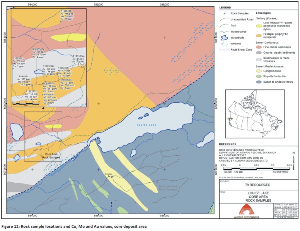
due-diligence visit confirmed the presence of Main Zone-style Cu-Mo-Au-Ag
mineralization, although grades were somewhat lower than those documented from
the Main Zone deposit. The remaining traverses failed to identify significantly
mineralized zones or major geochemical anomalies, although elevated Mo and
arsenic (As) values were returned from rock sampling of pyritic conglomerate units
near the terminus of the driveable logging road. Fairly widespread fine-grained
pyrite, associated with fractured to brecciated mafic volcanics, occurs near
the former logging roads.
Phase 2 comprised
a ground magnetic surveying program along east-west oriented lines centered on “Argillic
Hill”, an area of argillic (clay) alteration and pyritization in the southwest
property area. A total of 52.7 line km, including 3.45 line km of north-south
tie lines, was surveyed. The survey identified a NE-SW trending magnetic low
feature, which may represent a significant structural lineament. This separates
fairly linear magnetic signatures to the east from more arcuate features to the
west, possibly representing folded stratigraphy accreted onto to more linear
stratigraphy to the southeast of the lineament. The survey also revealed an
ovoid magnetic high signature coincident with “Argillic Hill” alteration
directly west of the magnetic low feature.
6 CONCLUSIONS
The Main Zone of
the Louise Lake deposit is a tabular body striking at 260˚ and dipping from 30o
to 40o to the north. The zone comprises disseminated and vein-associated grains
of chalcopyrite and enargite with late molybdenite-bearing quartz veining,
occurring within a series of tabular units of feldspar porphyritic monzonite
separated by sedimentary and volcanic units. The deposit model is an
upper-level portion of a Cu-Mo-Au-Ag porphyry system. By 2006, the Main Zone
was known to have dimensions in plan view of about 1000 m by 500 m, extending
to the horizontal “Terminator” fault at a depth of almost 300 m. Mineralization
does not appear to show any lithological preference, although improved
correlation of geological data is recommended.
In 2006, SRK
released the first NI 43-101 resource estimate. The estimate comprised an
Indicated Resource of 6 M tonnes grading 0.214% Cu, 0.006% Mo, 0.20 g/t Au and
0.98 g/t Ag, for a copper equivalent (CuEq) grade of 0.369%; and an additional
Inferred Resource of 141 M tonnes grading 0.234% Cu, 0.009% Mo, 0.20 g/t Au and
0.94 g/t Ag, for a CuEq grade of 0.426%. No reserves were included in this
resource estimate.
Later in 2006, a
metallurgical study by G & T Metallurgical Services Ltd. indicates that the
concentrate, with a “mass percent” of 0.8, contains 28.9% Cu at a recovery rate
of 85%. The concentrate also includes 0.650% Mo at an 80% recovery rate, 18.7
g/t Au, at a 55% recovery rate, and 364 g/t Ag, at a 44% recovery rate. Arsenic
(As) concentration was 11.4%, limiting potential for treatment by conventional
extraction techniques. A number of alternative extraction processes were
investigated in 2006, although no further progress has occurred since then.
Concentrations of other deleterious elements were minor.
A scoping study
by SRK, submitted in January 2008, indicated the project was not economically
viable at projected long-term metal prices, specifically a Cu price of
US$1.35/lb. At a Cu price of $3.00/lb, project economics improve, but economic
viability remained doubtful. North American Gem chose to respect the results,
and terminated the scoping study. Prices for Cu, Mo, Au and Ag in 2019 have
improved significantly, even when factoring inflation since early 2008, buoyed
by a favourable CDN$: US$ exchange rate. Long term price forecasts are required
when re-evaluating project economics.
The 2008 drilling
program successfully identified the underlying “fixed” portion of the deposit
to the westnorthwest. Another flat-lying fault, called the “Sub-Terminator”,
forms the basal unit of a mineralized tabular block. At least one other tabular
block occurs beneath this to the west. Thus, the original deposit has been
segmented into a series of blocks, each overlying segment successively
displaced farther to theeast-southeast. The Main Zone is hosted by the
easternmost single block which extends to surface.
Results from the
2008 summer surface exploration program revealed an area of quartz and
carbonate vein stockwork east of Bud Lake, with elevated Au values from nearby
stream silt sampling. A second prospective target is the “Arsenic Hill” area
northwest of Sandstone Lake. The “Louise Extension” claim currently covers
these targets.
Due diligence
rock sampling in 2019 across the surface expression of the Main Zone confirmed
the presence of Cu-Mo-Au-Ag mineralization, although the 2019 values are lower
than the deposit average. Geological mapping in the Bud Lake area did not
identify mineralization indicative of another porphyry centre, and no
significant mineralized zones were identified. Several rock samples of
conglomerate returned elevated Mo and As values and slightly elevated Cu
values. However, this is not considered a significant exploration target. The
“Argillic Hill” occurrence was not visited in 2019.
The Phase 2
ground magnetic survey identified an ovoid magnetic “high” feature, directly
west of the main NE-SW magnetic low feature, coincident with an area identified
in 2008 comprising argillic alteration, pyritization, and several elevated
gold-in-soil geochemical values. This may represent the overlying halo exploration
target.
7 RECOMMENDATIONS
It is strongly
recommended that 79 Resources acquires the claim (#1064060) held by Mr. B.
Kreft, through an option or purchase agreement. This claim covers part of the
Main Zone deposit and is required if the entire deposit is to be wholly-owned.
The 2020 program
is recommended to comprise two phases. Phase 1 would target the Argillic Hill occurrence,
and comprise a surface program of grid soil geochemical sampling, combined with
detailed geological mapping, rock sampling and prospecting. This program would
require a 4-person crew based from a field exploration camp. The program would
have a total duration of 12 days, including 6 days of actual field work, 2 days
of mobilization and de-mobe, and 4 travel days. Total Phase 1 expenditures, including
10% contingency, are estimated at about CDN$103,200.
The Phase 2
program would comprise a single 350-metre due diligence-style hole targeting
the Main Zone, designed to confirm the extent and tenor of Main Zone
mineralization. This phase would be completed using a single drill with two
shifts per 24 hours. The crew would be comprised of four drillers and three geological
and geotechnical staff. Drilling could be done in late winter, allowing for
travel across frozen wetlands if necessary, or in summer, if wetlands can be
avoided. None of the proposed drilling or support logistics would take place on
Claim #1064060. Phase 2 expenditures, including 5% contingency, are estimated
at about CDN$180,500. Proposed expenditures exclude payment for a necessary
reclamation bond but include reclamation costs. Expenditures also exclude PST
and the cost of acquiring Claim #1064060.
Dodaj komentarz