Amarc Resources Ltd. (TSXV:AHR), 6th May, 2020
- Update For The The Duke Project porphyry-style Cu-Au-Mo-Ag, British Columbia
- No Resources Estimated
1 Project Description, Location and Access
The DUKE Project (the “Project”, or “DUKE”)
comprises 76 mineral claims covering an area of 70,360.65 ha. The Project is
located in the Babine District of the Omineca Mining Division, central BC. The
centre of the Project lies approximately 85 km northeast of Smithers. Extensive
infrastructure exists in the area to support the forestry industry and the
construction of a new LNG pipeline, and also dates back to the nearby
past-producing Bell and Granisle Cu mines. As such, access is relatively easy
via an extensive and well maintained FSR network, which is accessed via
commercial barge that departs from Michelle Bay in Topley Landing, 9 km south
of the village of Granisle and 37 km north of the town of Topley, and arrives
into Nose Bay on the eastern shore of Babine Lake.
2. Ownership
The Project is 100% owned by Amarc
Resources Ltd (“Amarc”). The authors are not aware of any existing underlying
legal agreements, joint ventures, royalty agreements or partnerships on the
DUKE Project.
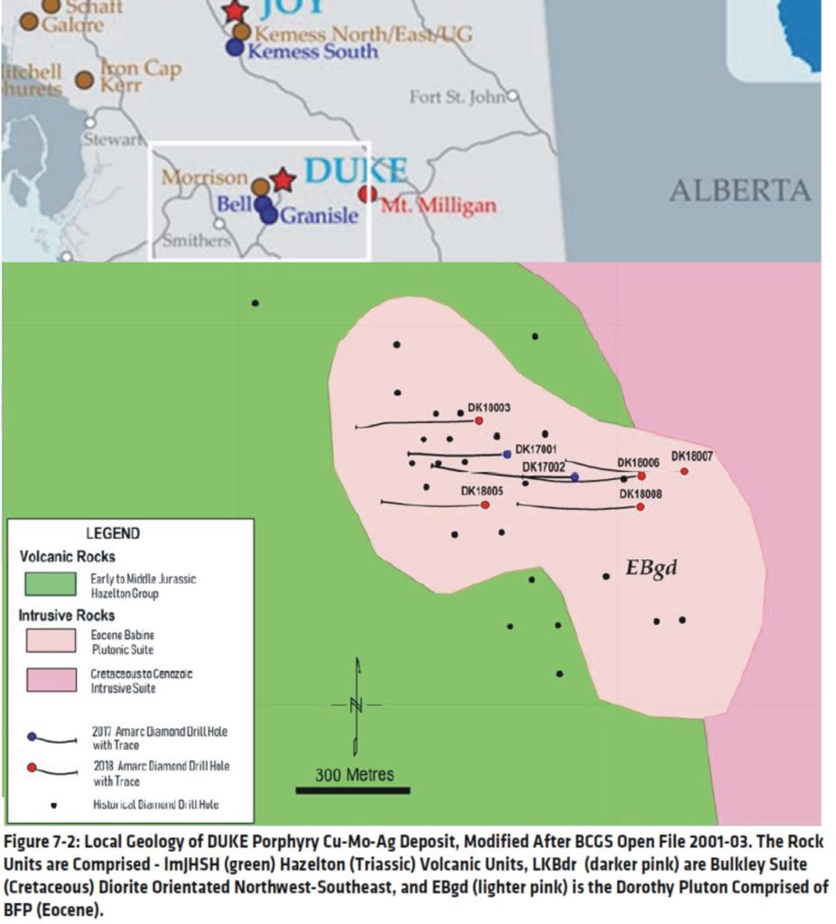
3. Geology and Mineralization
The exploration stage DUKE Project is
located within a belt of Tertiary and Cretaceous age porphyry Cu occurrences in
central BC (MacIntyre et al., 1997). The prospective Babine Intrusive Suite
intrudes Mesozoic volcanic and sedimentary rocks that comprise the Stikine
Terrane, which in turn lies within the Intermontane Tectonic belt of central
BC. The Babine Igneous Suite intrusions (biotite feldspar porphyry, “BFP”) are
central to the mineralization of the area. The Babine District is a 40 by 100
km north-northwesterly striking mineralized belt that hosts both the past operating
porphyry Cu-Au mines of Bell and Granisle, the advanced
stage Morrison porphyry Cu-Au deposit,
the NAK porphyry Cu-Au deposit, and the DUKE porphyry Cu-Mo-Ag deposit target. The
mineralization at the DUKE deposit target occurs within north and northwest-striking,
steeply dipping quartz – chalcopyrite } bornite
veinlets hosted by a Tertiary BFP, mafic volcanic sequences, and a previously undocumented
monzonite. Higher grades occur locally at, or adjacent to, contacts between the
intrusive phases and the volcanic and sedimentary host rocks of the Hazelton
Group. The DUKE porphyry is crosscut by porphyritic dykes, porphyritic
monzonite, and several intrusion breccias. Alteration is primarily potassic as
defined by the presence of secondary biotite after amphibole with little
evidence of significant Kfeldspar. Pervasive phyllic alteration overprints the
currently known potassic core of the deposit where sericite has commonly
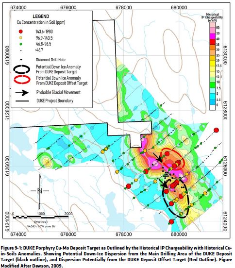
replaced plagioclase.The DUKE deposit target is located on the flank of a magnetic
high and displays a subtle magnetic signature. The porphyry hydrothermal system
has a large IP chargeability anomaly that measures 3 km by 1 km with chargeability
between 14–60 mV/V. The IP chargeability anomaly coincides with the magnetic
target. Currently, Amarc interprets the DUKE porphyry as a fault bisected
pregnant hydrothermal system offset by a younger regional northwest-trending
fault that crosscuts and offsets the deposit. A step-out hole (DK18004) drilled
by Amarc located and collared 1 km to the north of Amarc’s other drill holes,
investigated the possible dextral offset to the Cu-Mo-Ag}Au mineralization. This hole successfully encountered
mineralization grading 0.22% Cu, 0.01% Mo, and 1 g/t Ag over 93 m, so
confirming the presence of a largermineralized hydrothermal system.
4. Environmental, permitting, and community impact
The authors are not aware of any
existing environmental liabilities related to the DUKE Project. The Project is
currently permitted for exploration drilling at the DUKE deposit target and
geophysical surveys across the Project. These permits include all ancillary
permits to allow exploration work in the future. The DUKE Project is situated
within the asserted traditional territory of First Nations. Amarc works closely
with local First Nations and other project stakeholders in order to advance its
mineral properties responsibly, and seeks early and meaningful engagement to
ensure its mineral exploration and development activities are well-coordinated
and broadly supported, to address local priorities and concerns, and to
optimize opportunities for collaboration and local benefit.
Conclusions
The Babine District (or the “District”)
is one of BC’s most prolific porphyry Cu belts, with past producing Cu-Au mines
(Bell, Granisle) and a sizable advanced-stage project (Morrison). The District
is extensively covered by sequences of glaciofluvial and lacustrine cover. Although
historical workers located the outcropping porphyry Cu-Au mineralization, most
of the prospective ground lies under the Quaternary cover, which is thought to
be of variable thickness (0 m to 30 m). Amarc has staked a controlling position
across the district and is positioned to identify new porphyry Cu-Au-Mo-Ag
discoveries under cover. Amarc has identified the DUKE porphyry as a
significant and sizable Cu-Mo-Ag}Au
deposit-scale target. The company has completed 4,107 m of drilling since 2017.
Significant Cu mineralization was intersected, for example, 318 m of 0.24% Cu,
0.01% Mo, and 1.1 g/t Ag, including 58 m at 0.34% Cu, 0.02% Mo, and 1.5 g/t Ag.
Many of shallow historical drill holes completed at the DUKE deposit target
both intercepted encouraging grades and ended in mineralization. Amarc’s modern
drilling expanded the known mineralization laterally and to depth, with the
mineralization remaining open to expansion in all directions. The hydrothermal system,
as outlined by IP and drilling, is extensive, measuring 3 km by 1 km at
surface, of which only a small percentage has been drill tested to date. A
single step-out hole (DK18004) was drilled by Amarc to test a possible faulted
off-set target 1 km to the north of the previously Amarc drilling. This hole
returned anomalous grades of Cu-Mo-Ag including 93 m at 0.22% Cu, 0.012% Mo and
1.0 g/t Ag, and confirmed the hydrothermal system present at the DUKE deposit
is extensive in both volume and mineralization. Recent regional targeting has
identified 12 high-priority porphyry style exploration targets on the wider DUKE
Project tenure for field follow-up and potential drill testing. These new
targets are in addition to the known porphyry deposit target at DUKE and the
porphyry prospect at Trail Peak. These new targets were identified as areas
with anomalous Cu-Au-Mo-Ag and other porphyry indicator till geochemistry,
compelling up-ice magnetic features, and were structurally controlled along
secondary faults emanating from large deep-seated regional faults that likely
controlled the emplacement of the prospective Babine Intrusions.
Dodaj komentarz