Origen Resources Inc. (#TSXV:EX Explorex Resources Inc. - Spinco)
- Update For The Arlington Polymetallic Ag-Cu-Pb-Zn +/-Au deposit, British Columbia
- No Resources Estimated

SUMMARY
1. Introduction
This
report has been prepared for 1223104 B.C. Ltd (“Spinco”), a registered company
in the Province of British Columbia. The author, James Chapman, P.Geo., was
requested by Spinco, to provide an independent review and Technical Report. The
report discusses the mineral potential of the Arlington Project. The Arlington
Property is an exploration level project. There is no current or historical
mineral resource, mineral reserve estimate or production on or from the
Arlington property.
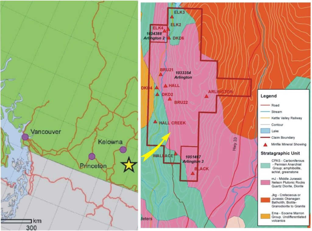
2. Location and Ownership
The
Arlington property is located in the Arrow Boundary District of south-central
British Columbia, Canada and is 17 kilometers north of the community of
Beaverdell and 67 kilometers south of the City of Kelowna. The property
consists of three Mineral Title-Online claims covering 649.31 hectares of land.
The claims are located on Mineral Titles map sheet 082/11 in the Greenwood
Mining Division and are in good standing until June 15, 2022. Explorex
Resources Ltd. acquired the property by on-line staking and owns a 100%
interest in the claims.
3. Geology and Mineralization
The
property covers geologically prospective ground just north of the historic
Beaverdell Mining camp and the past producing Carmi mine and hosts 13 Minfile
Occurrences associated with structurally controlled Polymetallic Ag-Cu-Pb-Zn
+/-Au veins. In this deposit style, veins can occur in virtually any host and
form steeply dipping, narrow tabular to splayed veins and commonly occur as
sets of parallel and offset veins. Individual veins may vary from a few
centimeters up to several meters wide and can be traced from a few hundred to
more than a kilometer in length. Locally the veins may widen to tens of meters
in stockwork zones.
The
Jurassic to Cretaceous aged Okanagan Batholith is the most prominent unit in
the region, bordering nearly all other rock types. Diorite and quartz diorite
of the Nelson Plutonic suite is genetically related to the Okanagan Batholith
and is the dominant lithology underlying the claims. The oldest unit in the district
belongs to the Carboniferous to Permian aged greenstone and quartz biotite
chlorite schist of the Anarchist group which occurs as a narrow north-south
trending bands along the west side of the property. The youngest unit on the
claim is the Eocene Marron Group. Chalcopyrite, sphalerite, galena and
molybdenum mineralization with values in gold and silver are found in shear
hosted quartz veins cutting altered diorite and quartz diorite intrusive rocks
and Anarchist Group stratigraphy.
4. Historic Exploration and Data
Historic
work on the property was driven by the early success and discoveries made in
the Beaverdell and Carmi Mining Camps located to the south of the property.
Historical work can be divided into four periods; an early period of activity
in the late 1890’s and early 1900’s is credited with the discovery of the known
zones of mineralization located to date on the property. Three eras of
historical exploration work were completed on the property during the early
1970’s, 1987 and 1996. More recently, field exploration programs were completed
on the property in 2015, 2017 and 2018. It is the author’s opinion that the
historical data is of sufficient quality and completeness to incorporate into
this 43-101 report. In June 2015, Explorex Resources Inc completed a 6-day
field program consisting of a 12-kilometer reconnaissance style magnetometer
and VLF-EM geophysical survey. Prospecting located nine historic Minfile
Occurrences and collected 14 rock samples from the located showings. In April
2017, Explorex Resources optioned the Arlington property to Clarmin Exploration
Inc. In May 2017 Clarmin completed 30.9km of gridding over which 657 B horizon
soil samples were collected and 26.4kilometers of magnetometer and VLF-EM
geophysical surveys were completed. The VLF-EM survey identified several
east-west to northeast-southwest conductive trends which are closely associated
with known zones of mineralization. Prospecting located 11 new historical
showings from which 44 rock samples were collected and submitted for analysis.
These returned from 0.05ppm to 211.0ppm Ag, 0.07ppm to 6.8ppm Au, 7.5ppm to
3.22% Cu, 0.43ppm to 1,795ppm Mo, 1.4ppm to 2,538ppm Pb and 6.0ppm to 9,268ppm
Zn. In May 2018, Clarmin extended the 2017 field grid over which an additional
268 B horizon soil samples and 7 rock samples were collected and submitted for
analysis. The soil sampling program extended anomalous copper and to some
extent silver soil results through the sampled area, and also evaluated the
area surrounding the Black Minfile occurrence located at the south end of the
property. Results of samples collected from the Black showing returned elevated
and anomalous results from 2.8ppm to 1.051% Cu, <0.005ppm to 37.65g/t Ag,
<0.001ppm to 0.13g/t Au and 1.78ppm to 3,556.44ppm Mo. The soil sample
results from the Black showing area returned elevated and anomalous silver soil
results as both single point and anomalous clusters.
5. Conclusions and Recommendations
The
author concludes that the property merits further exploration. A two-phase
exploration program is recommended to evaluate the known Minfile occurrences
both at depth and along strike. During the first phase program, 17.3km of the
pre-existing soil geochemical grid will be re-established by compass, GPS and
flagging. The grid lines will be installed at 100m centers while stations will
be emplaced at 50m intervals. A 2D Induced Polarization (IP) survey is to be
completed over the established grid with 50m dipoles totaling 17.3-line
kilometers. A Second Phase program is further recommended and is contingent on
the receipt of favorable I.P. results from Phase One. A 400-meter NQ diamond
drill program will drill test the favorable IP results. Total
expenditure of Phase 1 is $100,000 and Phase 2 total is $194,315.
Dodaj komentarz