Windfall Geotek Inc. (formerly Albert Mining) Ni 43 101, 1st May, 2020
- Update Report For The Chapais Property, Cu, Au, Quebec, Canada
- No Resources Estimated


Summary.
Albert Mining Inc. contracted Even Stavre P, Geo, in September 2019 to prepare an independent technical report for the company’s Chapais cooper-gold deposit, in accordance with requirements of National Instrument 43-101 (NI 43-101). The Chapais Property deposit is located approximately 400km northwest the town of Val D’Or, in the province of Quebec, Canada. The Chapais property addressed in this report consists of 36 mineral exploration claims that cover 1560.18 hectares (15.6 km2) of surface area.
The current technical report follows up the 2017 drilling program completed for Albert Mining in 2017 and consisted on testing Cu targets defined in 2010 by DIAGNOS Inc., with the use of its proprietary Computer Aided Resource Detection System (CARDS). The drilling program was performed in December 2017 and consisted of three drill holes totalling 671 m.
The current technical report include in its integral form some chapters from: (1) The previous 43-101 Technical Report written in March 2011 by André Ciesielski, P. Geo, and Jean-Philippe Mai, P. Geo (49 pages); and (2) The Technical Report about the 2017 drilling program written in January 2018 by Remi Charbonneau, P. Geo and Isabelle Robillard, P. Geo (GM 70604, 2018. 63 pages).
The Chapais Property lies within Chapais mining district, the Chapais-Chibougamau mining camp, and its mineralization style is part of Opemiska type copper-gold vein typology.
The Chapais-Chibougamau mining camp is the second largest mining district in the Quebec part of the Abitibi greenstone belt. The camp has produced approximately 86 million metric tonnes of ore from 1953 to 2008, including 1.57 million tonnes Cu, 176.1 tonnes Au, 108.8 tonnes Ag, and 72,066 tonnes Zn (Leclerc and al., 2012).
Ore production in this region has started in 1953 and ceased in 1991. Production tonnage was extracted from four mines, namely the Springer, Perry, Robitaille and Cooke mines. A total of approximately 600,000 short tons of copper, 216,000 ounces of silver and 529,000 ounces of gold have been produced from 26.6 million short tons of milled ore.
The Chapais Property is located in the northeastern Abitibi greenstone volcanic belt 2 km west of the town of Chapais. The area is underlain by Archean rocks of the Obatogamau and Gilman Formations (pillowed basalts and gabbro sills) and the Blondeau Formation (volcano-sedimentary assemblage). The Blondeau Formation is intruded by the Cummings Complex, which consists of three ultramafic and mafic sills, namely the Roberge, Ventures, and Bourbeau sills. Cumming Complex intrudes mafic and felsic rocks of the Waconichi Formations and mafic rocks of the upper Roy Group. Volcano sedimentary rocks of the Roy Group, a younger sedimentary sequence identified as the Opemisca Group and mafic to ultramafic intrusions, underlie Chapais Property. The Ventures sill comprises into five members, in this stratigraphic order, Lower Green Pyroxenite, Black Pyroxenite, Upper Green Pyroxenite, Foliated Gabbro, and Ventures Gabbro. The Springer mine is located in the Ventures Gabbro sill, which continues into Chapais property.
The property lies within a complex west northwest-trending anticline and folded and sheared homoclinal interstratified vertical sequences of basalts, gabbro, rhyodacites and pyroxenites. (NI-43-101 Report 2019).
Mineralization in the Chapais-Chibougamau area is classified into the following types (Leclerc and al., 2012):
- Syn-magmatic Fe-Ti-V and Ni-Cu platinum group element (PGE) mineralization in mafic-ultramafic layered complexes and sills. Fe-Ti-V deposits occur within the Layered zone of the Lac Doré Complex, especially where it thickens in areas of interpreted syn- magmatic faults. Sub-economic magmatic Ni-Cu deposits occur at the contacts of mafic-ultramafic or tonalitic intrusions.
- Syn-magmatic “Chibougamau-type” Cu-Au veins formed through magmatic- hydrothermal processes. They are cut by dikes that predate regional D2 deformation but are located within, and are deformed by, north-west and northeast rending D2 shear zones.
- Syn-magmatic early polymetallic Au-Ag-Cu-Zn-Pb veins associated with north/north- west to north/north-east-striking syn-volcanic faults.
- Syn-volcanic volcanogenic massive sulfide (VMS). VMS deposits occur within felsic volcanic rocks of tholeiitic affinity and mafic to felsic volcanic rocks of transitional to calc-alkaline affinity at the top of three volcanic cycles of the Roy Group. VMS deposits are associated with north/north-west to north/north-east-striking syn-volcanic faults.
- Shear zone hosted “orogenic” Cu-Au and Au.
- “Opemiska-type” Cu-Au veins occur within regional overturned anticlines in mafic sills of the Cummings Complex. Veins in the Chapais area are developed in east-west reverse D2 shear zones that parallel the axial surface of the Beaver Lake anticline in the upper gabbro of the Ventures sill. These veins are also reoriented into north-west/south-east D2 shear zones and faults.
Au deposits are developed preferentially within regional east-west–trending deformation corridors and along north/north-east-striking sinistral shear zones. Mineralization on the Chapais property may be of Opémiska style copper vein typology, particularly given its proximity to the Springer and Perry mines.
The abstract below is taken in its integral form from NI-43-101 Chapais Property Ciesielski and Mai 2011, p.5:
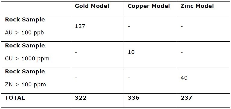
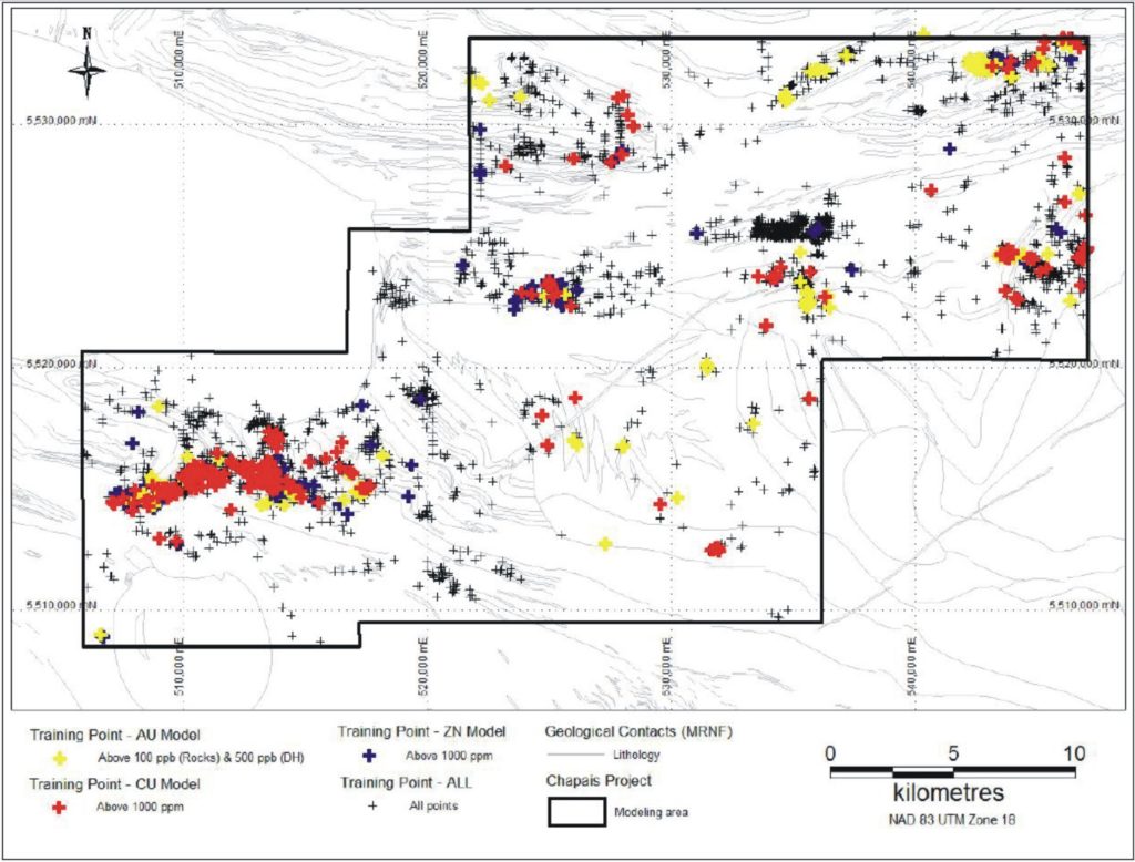
“During the months of April trough to May of 2010, over 704 km2 were subject to a CARDS (Computer Aided Resource Detection System) evaluation, carried out by DIAGNOS Inc., over the Chapais area. The purpose of this study was to identify favorable exploration targets based on the analysis of all available geophysical and downhole data using artificial intelligence and data mining techniques. The Chapais study area generated three different models; gold, copper and zinc models from which targets were identified on the property. The priority targets, selected based on their high similitude to the known gold, copper or zinc mineralization, remain untested and should be prioritized based on the evaluation of all available geoscientific information and be validated by a reconnaissance field survey. It should lead to further investigation using geophysics and definition of drill targets. The property is of value because it includes both a highly prospective region (northern section of the claim block) located in a geologically significant environment and a well worked region (southeast section of claim block) that could still benefit from further drill testing. Furthermore, over 60% of the 132 drill, holes located on the current claim block were extremely shallow, 34 never exceeded 100m depth and a further 49 did not exceed 200m”.
Dodaj komentarz